Sorry, you need to enable JavaScript to visit this website.
Skip to main content


Twin Data Centres: How UNGSC Safeguards Continuity of Critical Digital Services

Submitted by nestola on

On 29 October 2024, the eastern region of Spain, including the Valencia area, was hit by one of the most severe flood disasters in recent history. An isolated, high-altitude, low-pressure weather system (known locally as DANA) caused torrential rainfall that exceeded a year's worth of rain in less than eight hours. Rivers and ravines overflowed, urban infrastructure was overwhelmed, and the disaster resulted in hundreds of fatalities and widespread damage. This was not an ordinary storm.

High-Level Committee on Management Meeting

Submitted by Nadia Caputo on

This month, a UNGSC delegation was welcomed at the Palau de la Generalitat, in the framework of the High-Level Committee on Management meeting, which brought together colleagues from across the United Nations system.


The event provided an opportunity to engage with local authorities and partners supporting the UN presence in Valencia, where UN entities continue to expand their operations, now comprising nearly 750 personnel across UN premises in Valencia.

4th Annual Data and Visualization Workshop: From Governance to Operations 23–26 February 2026

Submitted by Nadia Caputo on

From 23 to 26 February 2026, the United Nations Global Service Centre (UNGSC), in collaboration with the Office of Information and Communications Technology (OICT) and partners across Headquarters and field missions, convened the 4th Annual Data and Visualization Workshop: From Governance to Operations. Bringing together geospatial experts, data officers, and operational stakeholders from across peace operations, the workshop marked a significant step in translating policy frameworks into practical, mission-ready implementation.

FRIM 3.0: Turning Infrastructure Data into Operational Insight

Submitted by nestola on

On 9–10 February 2026, the United Nations Global Service Centre (UNGSC) brought together 160 participants from 15 field missions and Headquarters to shape the next phase of the Field Remote Infrastructure Monitoring (FRIM) programme.
Over recent years, FRIM has expanded across UN missions, using connected sensors to monitor generators, fuel systems, water networks, and environmental infrastructure. This has created a reliable, mission-wide picture of how critical assets perform in real time.

Mapping Together: UN Maps at the Humanitarian Networks and Partnerships Week (HNPW)

Submitted by nestola on

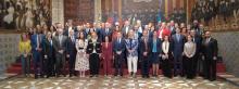
The United Nations Global Service Centre will take part in the 2026 edition of Humanitarian Networks and Partnerships Week (#HNPW), organized by United Nations Office for the Coordination of Humanitarian Affairs (#OCHA) — one of the largest global gatherings focused on solving operational challenges in humanitarian action.

On 5 March | 14:00–15:30 UTC, the UN Maps (on behalf of #UNGSC) team will host a remote session:

From Vision to Impact: Women Shaping UN Digital Operations

Submitted by Nadia Caputo on

At the United Nations Global Service Centre (UNGSC), advancing gender equality in science and technology is not an abstract principle — it is a measurable commitment. Over the past six years, the representation of women among our international staff has steadily increased from 28% in 2021 level to 46.1% on 2026 level (as of January 2026). This consistent upward trend reflects deliberate efforts to foster a more inclusive and balanced workforce across professional grades, strengthening both our operational effectiveness and our organizational culture. 

2nd Digital Twin Workshop - Scaling Digital Twin for Inclusive Innovation: From Prototype to Practice

Submitted by Nadia Caputo on

The Digital Twin Service (DTS) at UNGSC is enhancing how the United Nations plans, manages, and optimizes operations across field missions by creating dynamic, geolocated replicas of real-world environments, enriched with Internet of Things (IoT) and operational data, as well as field observations. This service enables advanced 3D visualization, Augmented Reality / Virtual Reality simulations, and predictive analytics.